Editor's Note: The Indiana Daily Student is now publishing national articles from our wire service. What does that mean? Read a letter from the editor about it here.
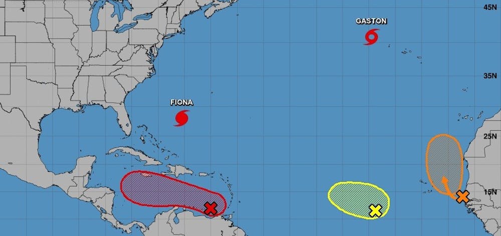
FORT LAUDERDALE, Fla. — A tropical wave located in the southeast Caribbean on Thursday has a high chance of becoming a hurricane in the coming days, according to the National Weather Service Miami.
In the next week, several long-term weather forecast models show the system turning north, passing over Cuba, and heading toward the Gulf of Mexico, and possibly toward Florida.
“It looks like it’s going to end up being a major hurricane,” said Will Redman, a spokesperson for the National Weather Service Miami.
A major hurricane is classified as Category 3 or above.
Redman said the current path shows the storm’s center anywhere between the west coast of Florida and New Orleans, while the area facing the brunt of the hurricane’s force would likely be the Florida Panhandle.
If a hurricane does develop, it would probably form Monday or Tuesday of next week, Redman said. The next named storm will be Hermine.
First, the tropical wave likely will become a tropical depression over the next few days while over the southeastern Caribbean Sea and then reach the central Caribbean this weekend, the National Hurricane Center’s 8 p.m. Eastern time advisory said. The system has a 90% chance of developing in the next 48 hours, up from 80% a few hours earlier, and a 90% chance of developing in the next five days.
The system’s showers and thunderstorms were disorganized Thursday night, but forecasters said the environment supports development as it heads west-northwest at 10 to 15 mph over the central Caribbean, according to the 8 p.m. update.
“It’s a good time to check any supplies and review your plans through the weekend,” the National Weather Service Miami wrote in its weekly weather briefing.
“For us here in South Florida, we just have to keep monitoring situation closely,” said Maria Torres, spokesperson for the National Hurricane Center. “The important thing is to make sure people start having their preparations ready.”
Meanwhile, Hurricane Fiona is holding steady as a Category 4 storm with 130 mph winds as of the 8 p.m. Thursday advisory. Several parts of Canada are under a hurricane watch, including Nova Scotia and Prince Edward Island. Bermuda remained under a hurricane warning Thursday. Fiona is the first major hurricane of the 2022 season, meaning Category 3 and above.
Fiona will start to lose strength Thursday night or Friday, forecasters said in the latest advisory, but will continue to be a large, powerful system into the weekend.
Forecasters are also monitoring two other systems in the Atlantic.
“The one to watch is definitely the system moving into the southeastern Caribbean,” said Eric Blake, a forecaster for the National Hurricane Center.
A tropical wave off Africa has been given a 60% chance of developing in the next five days, possibly becoming a tropical depression by this weekend, the National Hurricane Center said. And, a broad area of low pressure in the Atlantic has a 30% chance of developing in the next five days.
Tropical Storm Gaston also maintained its strength in the open Atlantic Ocean as of the 8 p.m. Thursday advisory. The storm is expected to move over or near the Azores through early Saturday, 1,000 miles off the coast of Portugal.
Forecasters expect Gaston to weaken throughout the next few days.
Hurricane season ends Nov. 30.


