
Editor's Note: The Indiana Daily Student is now publishing national articles from our wire service. What does that mean? Read a letter from the editor about it here.
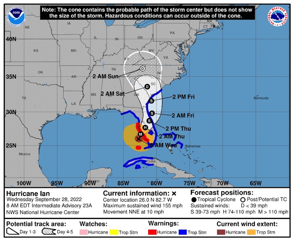
MIAMI — Ian strengthened early Wednesday into an extremely dangerous Category 4 hurricane, with 155 mph winds just a tick below Cat 5 strength and a wind field that covered almost half of the state. The hurricane is forecast to whip most of Florida with catastrophic winds, flooding rain and life-threatening storm surge as it gets closer to a west coast landfall Wednesday afternoon.
The storm surge predictions soared overnight to 12 to 18 feet for Englewood to Bonita Bay, a forecast so high a new color was added to the National Hurricane Center’s peak storm surge prediction map.
Wednesday morning, Ian’s outer bands were already battering Southwest Florida with gusts up to 75 mph. South Florida saw tornadoes overnight that flipped small airplanes and took down big trees, and Key West recorded one of its highest ever storm surge levels overnight. Sea water still remained in many neighborhoods, including on sections of famed Duval Street and inside homes.
“The storm is here. It is imminent,” the state’s director of emergency management, Kevin Guthrie, said on the Weather Channel.
As of the 11 a.m. update from the National Hurricane Center, Hurricane Ian had maximum sustained winds near 155 mph with higher gusts. To reach Cat 5, Ian needs to have maximum sustained winds of at least 157 mph.
Ian could still weaken before landfall but if not, it could rank among the most powerful storms to hit the United States.
Nine storms have reached Category 5 status while at sea but only four have made landfall at that strength in the U.S. — three of them in Florida. The most recent was Michael, which hammered the Panhandle in 2018. Andrew devastated South Miami-Dade in 1992 and an unnamed storm now known as the Labor Day hurricane swept the Florida Keys in 1935. Camille roared into the Mississippi coastline in 1969. All four of those Cat 5 hurricanes were tropical storms three days before landfall.
Ian was about 45 miles west-northwest of Naples and about 50 miles south-southwest of Punta Gorda, the hurricane center said in an 11 a.m. update. The storm was moving north-northeast near 9 mph, a slight slowdown.
Ian’s hurricane-force winds are expected to reach much of Florida’s Gulf Coast Wednesday morning, which has a hurricane warning in effect from Chokoloskee to the Anclote River, including the Tampa Bay region.
However, the storm is expected to slow down as it gets closer to Florida’s western coast, before making landfall Wednesday afternoon somewhere between Fort Myers and Sarasota as a powerful Cat 4 hurricane that NOAA called “monstrous.”
As of the 11 a.m. forecast, Ian’s center is heading to Port Charlotte and devastating wind damage is expected near the storm’s core. Weakening is expected once it makes landfall, with the storm expected to move over Central Florida Wednesday night and Thursday morning and emerging over the western Atlantic by late Thursday.
The latest update from the hurricane center extended hurricane warnings on Florida’s northeast coats, a signal that Ian could be an intact hurricane as it crosses the state.
Storm surge totals jumped up overnight and again Wednesday morning. The middle of Englewood to Bonita Beach, including Charlotte Harbor, is forecast to see the most storm surge, with 12 to 18 feet possible.
Bonita Beach south to Chokoloskee could see eight to 12 feet of storm surge.
“No one alive has seen 12 feet of storm surge in that area, and many areas could take years to recover. Please be safe!” tweeted Eric Blake, a senior meteorologist for NHC.
Ian, which already devastated Cuba Tuesday when it was a Category 3 hurricane, is a large and powerful storm. The Cat 4 storm’s hurricane-force winds extend up to 45 miles from the center and tropical-storm-force winds extend up to 175 miles.
That’s why all of Florida’s east coast, including South Florida, which has already been feeling some of Ian’s effects, particularly in the Keys, is under a tropical storm warning. The Dry Tortugas is under a hurricane warning.
Ian will also be a rainmaker. The hurricane center predicts up to 12 inches in South Florida and up to 24 inches for central and northeast Florida.
“Heavy rainfall will spread across the Florida peninsula through Thursday and reach portions of the Southeast later this week and this weekend. Catastrophic flooding is expected across portions of central Florida with considerable flooding in southern Florida, northern Florida, southeastern Georgia and coastal South Carolina,” the hurricane center said. “Widespread, prolonged moderate to major river flooding expected across central Florida.”
Key West broke a storm surge record overnight with more than two feet of storm surge, the third-highest water level on record behind 2005’s Wilma and 2017’s Irma, tweeted Jeff Masters, a meteorologist and former Hurricane Hunter.
The Key West office of the National Weather Service said the Keys saw three to five feet of storm surge on the Atlantic side of the island chain late Tuesday and a similar surge is expected Wednesday for the Gulf side.
For Southwest Florida, 2004’s Hurricane Charley is the yardstick for the worst storm they’ve lived through. The Category 4 storm came through like a small buzz saw, crossing the state and exiting near New Smyrna Beach.
Charley killed 30 Floridians and caused more than $5 billion of damage. Power was out for weeks in some spots, and public schools were closed for two weeks in some central Florida counties.
Now another strong storm is closing in on the same region, but meteorologists and emergency managers are warning residents that it’s not the same storm. Ian will be slower, bigger and wetter than Charley, and the population of the region has grown dramatically, putting more people in the bullseye.
“This is not Hurricane Charlie, but something you have never experienced,” tweeted Craig Fugate, who led the state’s emergency management response to Charley in 2004. “SW Florida, you are running out of time, if you are still in an evacuation zone, move inland.”
Wednesday morning, Hurricane Ian’s eye was around 17 miles wide, already much larger than Charley’s tight 7-mile wide eye was when it made landfall in Punta Gorda.
Ian’s wind field was also far larger, with hurricane-force winds extending 40 miles from the center and tropical-storm-force winds extending up to 175 miles. Charley’s wind field was far smaller, with tropical storm winds extending out around 70 miles from the center.
“As of 5am Wednesday, Ian’s area of hurricane-force winds is 2.9 times larger, and its area of tropical storm force winds is 2.3 times larger,” tweeted Brian McNoldy, a senior research associate at the University of Miami.
Charley also rushed through the state as an unusually fast storm, with speeds of 20 to 25 mph. Hurricane Ian is forecast to be much slower, with speeds from 10 mph to 5 mph. That slowdown will allow it to dump incredible amounts of rain across most of the state and push “catastrophic” levels of storm surge ashore.
Charley brought 5 to 8 inches of rain to the state, while Ian could bring up to 24 across most of central Florida.
A final factor that could make Hurricane Ian far more devastating than Charley is the number of people and buildings at risk.
Population in the counties closest to landfall has grown by more than half a million since 2004, tweeted Matt Lanza, a meteorologist for Space City Weather in Houston.


